


Geography
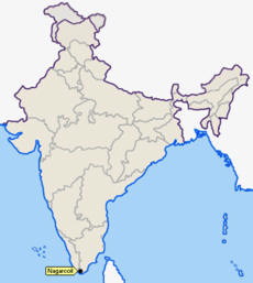
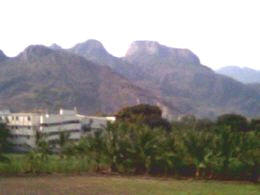
Nagercoil is located at 8.18° N 77.43° E at the southern tip of peninsular India. Since its close proximity to the Western Ghats, the area is generally hilly. The Western Ghats is the lifeline of the town, with water sources for irrigation and drinking, climate, eco-system and biodiversity, and the local economy to a great extent (like rubber cultivation, etc), being influenced by this mountain range.
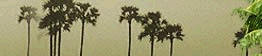
Sandwiched between the Arabian Sea and the Western Ghats, the town has some breathtaking sceneries of the surrounding hills (the Western Ghats), lush green paddy fields on the eastern side of the town, and sandy, palm-fringed beaches on the western side. A common sight to the east of Nagercoil would be the plantations of rubber, cloves and cardamom. Many of these plantations were developed by the British (rubber-plant was introduced by the English missionaries) in the pre-Indian independence days. Some of these plantation estates are still owned by the descendants of these British planters. A majority of the estates are also owned by the influential Mapillai community (Syrian Christians) of Kerala.
Being close to the cape, the town is the intersection of the eastern and western lines of the Indian Railways with one line leading through Kerala called the Konkan route and the other through the eastern part of India (through Tirunelveli of Tamilnadu). Nagerocil is 65 km from Trivandrum (the capital of Kerala) connected by National Highway 47 and 80 km from Tirunelveli connected by National Highway 7.
Connectivity:
» Through air : The nearest airport is at Trivandrum (80 km). It is
directly connected with Bangalore, Bombay, Cochin, Delhi, Goa, and Madras by
regular flights.
» Via railways : Kanyakumari is connected to Trivandrum, Delhi, and
Bombay by broad-gauge railway network. Tirunelvelli (80 km) is the other
nearest railway junction and can be reached by road via Nagarkoil (19 km).
» By roads : Kanyakumari is connected by road to Trivandrum (86 km),
Nagarkoil (19 km), Tirunelvelli (91 km), Tiruchendur (89 km), Tuticorin (129
km), Rameshwaram (300 km), Courtallam (130 km), Madurai (242 km), Thekkady
(358 km), Kodaikanal (362 km), Palani (370 km), Ootacamund (576 km), Cochin
(309 km), and Coimbatore (478 km).
Climate
Nagercoil has a pleasant climate for most part of the year. The maximum temperature during summer hovers around 30 degrees Celsius. Nagercoil is benefited by both the north-east monsoon and the south-west monsoon. It rains more often in this district than any other place in Tamil Nadu, with the exception of the Niligiris. The southern tip of Kanyakumari is generally 2 °C to 3 °C warmer than Nagercoil during daytime, though Kanyakumari is only 20 km away. Another peculiar feature is, it rains often in the interior regions (Nagercoil and near the hills) during the monsoon season, while the cape (Kanyakumari) gets scanty rainfall.
Demographics
Though the official population count (for the municipal area) is close to 2.25 lakhs, a sizable population lives around the town, making the small district of Kanyakumari, with a population of about 17 lakhs, one of the most densely populated districts in Tamilnadu and in South India.
Culture
Tamil, Malayalam(due to its proximity to Kerala) and English is widely spoken by the people. These three languages are used as a medium for teaching in all the major schools.
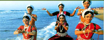
The culture is a mixture of Tamil Nadu and Kerala. Being multi-ethnic, festivals of different ethnicity are celeberated.
Christanity, Hinduism and Islam is widely practised. Some of the prominent festivals that are celeberated here are Ayya Vaikunda Avataram festival at Swamithope, Onam, Christmas, Bhagavathy Amman Temple festival, St. Francis Xavier's feast, the Peer Mohammed Durgah at Thuckalay among others.
Influence of European missionaries
The arrival of English, German and other Western Christian missionaries in the 19th century and the development of social infrastructure by the Travancore monarchs raised the social status, literacy and educational levels of the people. Today, one finds a number of streets, schools and colleges in the town named after these European missionaries. Many of these missionaries were also noted scholars.
The European missionaries preached the importance and value of education even as early as the 19th century, because of which the socio-economic factors developed. They also converted a section of the people to Protestants. The Portuguese missionaries were responsible for converting the locals to Roman Catholics in the 16th and 17th centuries.
Of the European missionaries, the services of two missionaries are particularly laudable. One is Rev C. Mead, who after arriving in 1817 in Nagercoil, as a missionary of the London Missionary Society (LMS), made immense contributions to the cause of education in the town and in Travancore. In 1818, he founded the Nagercoil Seminary, which became one of the first regular institutes to impart English education in Travancore state and also in Southern India. In 1855, in recognition for his contributions to education, the Travancore Government appointed him Superintendent of Schools, and while in this office, he furthered the cause of education and also encouraged female education in Nagercoil and in the state of Travancore. He also started the Nagercoil Mission Press, the first printing press in the state of Travancore. Rev. Mead also fought to abolish slavery.
The other great missionary was Rev. William Tobias Ringeltaube, a native of the then Prussia (present Germany), who from 1806 to 1816 established a number of schools and worked among the poor. He started one of the first regular schools in Travancore at Mylaudy, near Nagercoil and is still active at Mylaudy.
Like the London Mission Society (LMS), another organisation that rendered valuable services to the cause of education and upliftment of the socially downtrodden was the Christian Mission Society (CMS). Both these societies still have a presence in Nagercoil (after nearly two centuries).
Local Economy
Nagercoil is the headquarters of the state owned Rubber Corporation and the regional office of the Central Rubber Board.
The Indian Space Research Organisation (ISRO) has a major testing facility for Cryogenic and Liquid Propulsion rocket engines on the Mahendragiri hills (on the Western Ghats) off Nagercoil. A number of rocket scientists and engineers from all over India work at this facility, called the Liquid Propulsion Systems Centre (LPSC).
The town also serves as a centre for the Koodangulam Nuclear Power Plant reactors, being built with Russian assistance, which is situated in Tirunelveli district of Tamilnadu, but is the closest major town to the facility.
The public sector Indian Rare Earths Ltd (IRE), also has a major facility at Manavaalakurichy, near the town.
Aralvaimozhy, near the town is a major centre for renewable-energy production, with thousands of wind-mill electricity generators on tall towers dotting the entire area. The total power generated from these wind mills are 540 MW with each wind mill generating a power output of nearly 1.65 MW. The wind mills are erected and technically-supported by multi-national majors in the field of renewable energy like Suzlon, Micon, etc. The steady flow of wind for these wind-mills is made possible because Aralvaimozhy is situated on a mountain gap (pass) in the Western Ghats, through which the wind gushes, throughout the year.
Cottage and small scale industries include coir-making, handloom-weaving, rubber products, fish-net manufacturing (exported on a large scale), food-processing units, lace-making (export-oriented), etc.
Being the major Tamilnadu town closest to the Kerala capital, Thiruvananthapuram (Trivandrum) (65 km away and the closest airport to Nagercoil), trading and sending supplies to Kerala and Trivandrum is a major activity for the bustling markets at Vadasery and Kottar (availability and many items being cheaper in Tamilnadu than in Kerala adds to the thriving business).
Education
Some schools and colleges in Nagercoil are more than 150 years old, built by the foreign missionaries. This includes the Scott Christian College.
As explained above, European missionaries, in the 19th century and early 20th century stressed the importance of education to the people of the town and district.
Educational institutions include a number of private Engineering colleges, the Government-run Kanyakumari Medical College, Polytechnic colleges and Arts and Science Colleges. As in neighbouring Kerala, women's education and career-development are given importance almost on par with men, by all communities, especially among the Christians.
Several Colleges are run by Christian denominations and includes the St. Xavier's Catholic College of Engineering, CSI Institute of Technology, Scott Christian College (Arts and Sciences College, but with some specialised departments), Holy Cross College for Women, Women's Christian College, etc.
The South Travancore Hindu College and Sivanthi Aditanar College in the town are major Hindu Arts and Sciences colleges.
The Noorul Islam College of Engineering at Kumaracoil, near the town, is a noted institution for its facilities and management education programs.
Media
The town is served by an All India Radio (AIR) station (FM) and a Doordarshan relay station. The entire district is networked for Cable TV operations, with one major operator. Mobile phone coverage of most mobile operators cover the whole district, except the forested areas on the east. Maalai Malar is a locally published evening newspaper.
Places of interest
- Kanyakumari, the Land's end, and the confluence of the three water bodies, is 20 km to the south of Nagercoil, with tourist attractions of its own which include the Vivekanda Rock Memorial, 133 ft high statue of Tamil poet-saint Tiruvalluvar - both on the mid-sea on rocky islands; the place is also famous for its distinctly beautiful (reddish) sunrise.
- Nagercoil is 19 kms from Kanyakumari on the way to Padmanabhapuram.
- Vattakkotai, or Circular Fort, is a fort near Kanyakumari, right on the sea-shore. The portion running into the area is the most strongly built under the orders of De Lannoy during the reign of Mathandavarma (1729-58 AD). The view from the top of the fort, of the sea and the palm-fringed beach below, is fantastic.
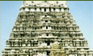
- Suchindrum (Thanumalayan) Temple, about 6 km from the heart of town and Nagaraja Temple (in the town), are some tourist attractions within the town.
- St. Xavier Church, (Kottar, Nagercoil), built in the year 1600 AD, has historic importance due to the visit of St.Francis Xavier from Goa. The church was built in the land alloted to St. Xavier by the venad king.
- Swamithoppe Ayya Vaikundar Pathi, about 11 km from Kanyakumari, which is the religious headquarters of Ayyavazhi, is well known for its non-idolatory system of worship.
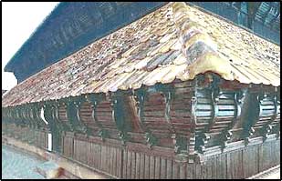
- Padmanabhapuram Palace (22 km from Nagercoil), once the seat of the Travancore kings, is India's only palace made completely of wood (16th century).
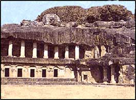
- Chitharal Jain Monuments (about 25 km), impressive rock shelters and idols dated 9-11th Century.
- Thirunandikkara temple (about 20 km), rock-cut cave temple of Pallava art can be traced back to seventh and eighth century AD.
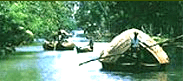
- Thengapattinam Beach. This beach is located on the west coast near Painkulam village in Vilancode Taluk. It is a fine beach adorned with coconut groves. It is also a magnificent estuary where the river meets the sea. Riding in a catamaran (small boat) in the river can be a pleasant experience which can be arranged through a local fisherman. It is 35 km from Nagercoil, 12 km from Kuzhithurai and 54 km from Kanniyakumari.
- Udayagiri Fort, built by the Travancore kings around 1741 AD, is a fort previously used for training the Travancore forces and also served as Barracks. Capt. De Lenoy's (see History section) tomb is within the fort. The fort (about 90 acres and almost full of vegetation now, with several plants, reptiles, etc.) is presently declared as a bio-diversity park and maintained by the Kanyakumari forest department.
- Mathur Hanging Trough, near Thiruvattar in the District carries irrigation water through a canal between two hills with a one kilometre gap in between (the hills). Built on very high pillars, it is said to be one of the biggest Aqueducts in South Asia. The view from the middle of the aqueduct of the surrounding hills and vegetation and the small river flowing down below is simply superb.
- Olakaruvi waterfalls, about 20 km from Nagercoil is on the middle of a hill and requires an hour's trek by foot from the base of the hill (better to go in a group, as it is a forested area)
- Keeriparai - for nature-lovers and adventurers, there are some good places (like Keeriparai) - still virgin - these places are not publicised by the Forest Department for various reasons - Keeriparai hills (30 km) and the nearby Kalikesam are good picnic spots - one can enjoy water rushing through small mountain streams, ferns and pebbles in the rainforests. There are small waterfalls in several areas here - the popular one being Vattaparai. Mountain squirrels, Jungle fowls, various snakes and other reptiles are among the fauna at Keeriparai. Wild elephants could be seen further up the hills.
- Kodhayar (called Kodhayar Lower Camp) - about 60 km by mountain roads (motorable roads) with some thrilling 'hair-pin bends' and U-turns - bisons and bears are famous in this area. Access to some areas need prior permission from the Forest Department.
- Pechiparai Reservoir, about 30 km from the town, in the hills, and also Perunchaani and Chittar dams are a must-see for the nature-lover (with clouds touching the top of the hills around the dams on a misty day !).
- Thiruparrapu Falls, is another good waterfalls, but the 'natural ambiance' is now gone, with many artificial make-overs and over-crowding of tourists.
- Muttom, a coastal village, is another place popular with tourists. The terrain in this village and its surroundings is hilly and from a height one can see an idyllic view of the place, with a Portuguese style church standing in the middle of the village. The beach-area is somewhat rocky. There is also a 100-year old lighthouse. The lighthouse, though near the sea, is situated on a land mass some 105 feet above sea level. The lighthouse originally came up here in olden days, because of the presence of a huge rock, near Muttom called 'Crocodile Rock'. Another attractive feature of this area, is a ravine-like area with reddish earth (soil) and casurina trees near the sea-side. This place with very popular with Tamil and Keralite film-makers.
- Sanguthurai Beach, about 8 km from the town is a palm-fringed and sandy beach. Sothavilai Beach is another good beach, about 7 km from the heart of town. It is sandy, but hit by the Indian Ocean Tsunami. There is a very good lagoon (estuary - place where the river meets the sea) at Manakudy - 10 km from the town.
Fresh water supply to the town is from the Mukkadal Reservoir, about 8 km from the town, in the interior - itself a very scenic place, with a small bushy island in the middle of the dam. The dam is surrounded by hills of the Western Ghats.
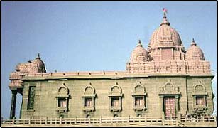
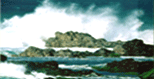
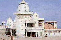
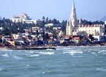 THE LAND'S END
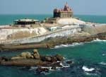
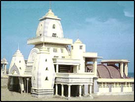 ntaining the ashes of
Mahatma Gandhi was kept for public view before a portion of its contents was
immersed in the three seas. It resembles an Oriyan temple and was designed so
that on Gandhiji's birthday (2nd October), the sun's rays fall on the place
where his ashes were kept.
ntaining the ashes of
Mahatma Gandhi was kept for public view before a portion of its contents was
immersed in the three seas. It resembles an Oriyan temple and was designed so
that on Gandhiji's birthday (2nd October), the sun's rays fall on the place
where his ashes were kept. 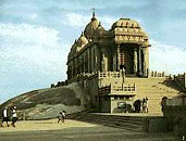 emorial
: It is about 500 meters away from mainland.
This memorial stands on one of two rocks separated by about 70 meters. It was
built in 1970. This memorial is dedicated to Swami Vivekananda, the greatest
social reformer. Swamy Vivekananda was supposed to have medicated on the rock
where the memorial stands today. A meditation hall is also attached with the
memorial. The design of the mandapa incorporates different styles of temple
architecture from all over India. It houses a statue of Vivekananda. The
divine foot print 'Pada Parai' of Devi is also seen here. Ferry service is
available to reach the memorial. It opens from Wednesday to Monday. Tuesday is
holiday. It opens from 0700 to 1100 and from 1400 to 1700.
emorial
: It is about 500 meters away from mainland.
This memorial stands on one of two rocks separated by about 70 meters. It was
built in 1970. This memorial is dedicated to Swami Vivekananda, the greatest
social reformer. Swamy Vivekananda was supposed to have medicated on the rock
where the memorial stands today. A meditation hall is also attached with the
memorial. The design of the mandapa incorporates different styles of temple
architecture from all over India. It houses a statue of Vivekananda. The
divine foot print 'Pada Parai' of Devi is also seen here. Ferry service is
available to reach the memorial. It opens from Wednesday to Monday. Tuesday is
holiday. It opens from 0700 to 1100 and from 1400 to 1700. 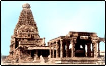
 ce
:
ce
: The Udayagiri Fort
(34 km), built by King Marthanda Varma (AD 1729-1758), has a foundry for
casting guns. The king's trusted European general De Lennoy's grave is located
within this fort.
The Udayagiri Fort
(34 km), built by King Marthanda Varma (AD 1729-1758), has a foundry for
casting guns. The king's trusted European general De Lennoy's grave is located
within this fort.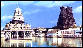
 Picturesquely
situated overlooking the shore, this temple and the nearby ghat attract
pilgrims from all over India to worship and to bathe. according to legend,
Devi did penance here to secure siva's hand in marriage. when she was
unsuccessful, she vowed to remain a virgin (kanya). The temple is open daily
from 4.30 to 11.45 am and from 5.30 to 8.30 pm, but non-Hindus are not
allowed into the inner sanctrum. Men must remove their shirts, and everyone
their shoes on entering the temple.
Picturesquely
situated overlooking the shore, this temple and the nearby ghat attract
pilgrims from all over India to worship and to bathe. according to legend,
Devi did penance here to secure siva's hand in marriage. when she was
unsuccessful, she vowed to remain a virgin (kanya). The temple is open daily
from 4.30 to 11.45 am and from 5.30 to 8.30 pm, but non-Hindus are not
allowed into the inner sanctrum. Men must remove their shirts, and everyone
their shoes on entering the temple.